Geolocate

Omaha topographic map

Click on the map to display elevation.

About this map

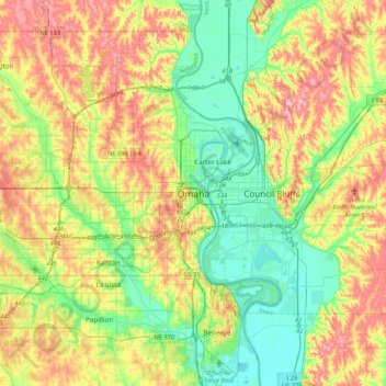
Name: Omaha topographic map, elevation, terrain.

Location: Omaha, Douglas County, Nebraska, 68183, United States (41.09875 -96.09838 41.41875 -95.77838)

Average elevation: 339 m

Minimum elevation: 289 m

Maximum elevation: 412 m

Other topographic maps

Click on a map to view its topography, its elevation and its terrain.

Memorial Park

United States > Nebraska > Douglas County > Omaha

Average elevation: 354 m

Gear up for your next adventure:

🧥Ultralight Puffy Jacket - Maximum warmth that packs down to the size of an orange
🥾Lightweight Hiking Shoes - Comfortable shoes for day hikes
🌡️Emergency Mylar Blankets - Compact thermal protection for unexpected nights outdoors
🐕Hiking Dog Pack - Let your canine companion carry their own water and food
Camping Coffee Maker - Brew fresh coffee anywhere on the topographic map

As an Amazon Associate, this site earns from qualifying purchases at no extra cost to you.