Geolocate

Sonora topographic map

Click on the map to display elevation.

About this map

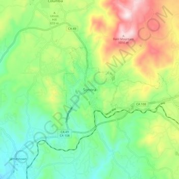
Name: Sonora topographic map, elevation, terrain.

Location: Sonora, Tuolumne County, California, United States (37.94409 -120.42214 38.02409 -120.34214)

Average elevation: 632 m

Minimum elevation: 410 m

Maximum elevation: 1,034 m

Gear up for your next adventure:

🧥Softshell Hiking Jacket - The perfect balance of wind protection and breathability
🥾Light Hiking Boots - Lightweight and comfortable boots for day hikes
🧼Travel Hand Sanitizer - Keep hands clean when water is scarce
Backpacking Tent - Lightweight tent for long-distance hiking trips
🥾Waterproof Trail Shoes - Shoes designed to handle wet terrain

As an Amazon Associate, this site earns from qualifying purchases at no extra cost to you.