Geolocate

Pettino topographic map

Click on the map to display elevation.

Pettino

It stands at an elevation of 1074 metres above sea level. At the time of the Istat census of 2001, it had only 74 inhabitants.

Wikipedia (CC-BY-SA 3.0)

About this map

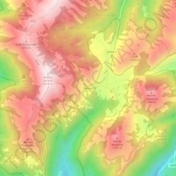
Name: Pettino topographic map, elevation, terrain.

Location: Pettino, Campello sul Clitunno, Perugia, Umbria, 06042, Italy (42.84289 12.79229 42.88289 12.83229)

Average elevation: 1,141 m

Minimum elevation: 730 m

Maximum elevation: 1,417 m

Gear up for your next adventure:

🧤Thermal Hiking Gloves - Grip-enhanced gloves for cold-weather altitude trekking
🥾Mountain Hiking Shoes - Shoes with superior grip for mountainous terrain
🥾Lightweight Hiking Shoes - Comfortable shoes for day hikes
🥾Trail Hiking Boots - Supportive boots for rough trails
🎒Hiking Daypack - Lightweight and durable backpacks for day trips and excursions

As an Amazon Associate, this site earns from qualifying purchases at no extra cost to you.