
Thank you for supporting this site ❤️
Make a donation
Make a donation
Gear up for your next adventure:
As an Amazon Associate, this site earns from qualifying purchases at no extra cost to you.
Montegrande topographic map
Click on the map to display elevation.
Thank you for supporting this site ❤️
Make a donation
Make a donation
Gear up for your next adventure:
As an Amazon Associate, this site earns from qualifying purchases at no extra cost to you.
About this map
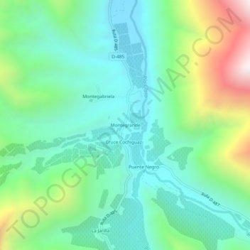
Name: Montegrande topographic map, elevation, terrain.
Average elevation: 1,391 m
Minimum elevation: 1,040 m
Maximum elevation: 2,312 m
Thank you for supporting this site ❤️
Make a donation
Make a donation
Gear up for your next adventure:
As an Amazon Associate, this site earns from qualifying purchases at no extra cost to you.
Other topographic maps
Click on a map to view its topography, its elevation and its terrain.
rio claro (elqui)
Chile > Región de Coquimbo > Provincia de Elqui > Paihuano
Average elevation: 2,406 m
Santuario de la Naturaleza Río Cochiguaz
Chile > Región de Coquimbo > Provincia de Elqui > Paihuano
Average elevation: 3,721 m