Geolocate

Camillus topographic map

Click on the map to display elevation.

About this map

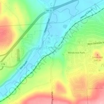
Name: Camillus topographic map, elevation, terrain.

Location: Camillus, Onondaga County, New York, United States (43.03215 -76.31779 43.04389 -76.29979)

Average elevation: 177 m

Minimum elevation: 120 m

Maximum elevation: 262 m

Gear up for your next adventure:

🥽Outdoor Goggles - Protective eyewear for outdoor activities
🥾Waterproof Trail Shoes - Shoes designed to handle wet terrain
🥾Hiking Gaiters - Protect legs and shoes from mud, snow, and debris
🩹Compact First Aid Kit - Pre-packed essentials for common trail injuries
🔋Emergency Crank Radio - Weather alerts and power without needing batteries

As an Amazon Associate, this site earns from qualifying purchases at no extra cost to you.