Geolocate

Kingsbury topographic map

Click on the map to display elevation.

About this map

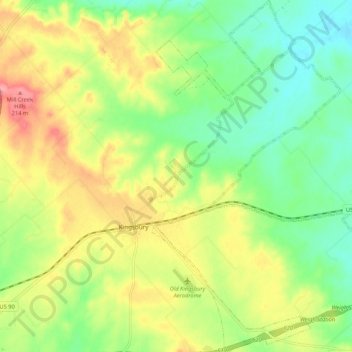
Name: Kingsbury topographic map, elevation, terrain.

Location: Kingsbury, Guadalupe County, Texas, United States (29.61551 -97.82282 29.70750 -97.74885)

Average elevation: 166 m

Minimum elevation: 125 m

Maximum elevation: 222 m

Other topographic maps

Click on a map to view its topography, its elevation and its terrain.

Haeckerville

United States > Texas > Guadalupe County > Cibolo

Average elevation: 213 m

Zorn

United States > Texas > Guadalupe County

Average elevation: 169 m

Gear up for your next adventure:

🥾Mountaineering Boots - Supportive boots for climbing and high-altitude hiking
🚲Heavy Duty Bike Lock - Secure your bike at the trailhead or during stops
🧥Insulated Jacket - Keep warm in cold outdoor conditions
🪜Heavy Duty Carabiners - Multi-use clips for securing gear to your backpack
🎒Hiking Backpack - Lightweight and ergonomic backpacks for day hikes or multi-day treks

As an Amazon Associate, this site earns from qualifying purchases at no extra cost to you.