Geolocate

Daine I topographic map

Click on the map to display elevation.

About this map

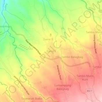
Name: Daine I topographic map, elevation, terrain.

Location: Daine I, Indang, Cavite, Calabarzon, 4122, Philippines (14.16793 120.82504 14.20793 120.86504)

Average elevation: 265 m

Minimum elevation: 142 m

Maximum elevation: 353 m

Other topographic maps

Click on a map to view its topography, its elevation and its terrain.

Bancod

Philippines > Cavite > Indang

Average elevation: 241 m

Kaytapos

Philippines > Cavite > Indang

Average elevation: 308 m

Banaba Cerca

Philippines > Cavite > Indang

Average elevation: 222 m

Buna Cerca

Philippines > Cavite > Indang

Average elevation: 333 m

Banaba Cerca

Philippines > Cavite > Indang

Average elevation: 222 m

Kaytapos

Philippines > Cavite > Indang

Average elevation: 308 m

Gear up for your next adventure:

🥾Trail Running Shoes - Lightweight and durable shoes for trail running
🥾Trail Hiking Shoes - Durable shoes designed for rugged trails
🔭Outdoor Binoculars - Lightweight binoculars for birdwatching and hiking
🔦LED Flashlight - Powerful and long-lasting flashlight for camping and emergencies
🧴Insect Repellent - Protect yourself from bugs during outdoor adventures

As an Amazon Associate, this site earns from qualifying purchases at no extra cost to you.