Geolocate

Santa Catarina topographic map

Click on the map to display elevation.

About this map

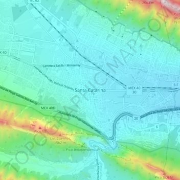
Name: Santa Catarina topographic map, elevation, terrain.

Location: Santa Catarina, Nuevo León, 66350, Mexico (25.63451 -100.50164 25.71451 -100.42164)

Average elevation: 842 m

Minimum elevation: 624 m

Maximum elevation: 1,987 m

Gear up for your next adventure:

🧥Softshell Hiking Jacket - The perfect balance of wind protection and breathability
Camping Coffee Maker - Brew fresh coffee anywhere on the topographic map
🧦Crew Hiking Socks - Comfortable socks for long-distance hikes
🧦Thermal Socks - Warm socks for winter hiking or camping
💧Reusable Water Bottle - Durable water bottles for hydration on trails

As an Amazon Associate, this site earns from qualifying purchases at no extra cost to you.