Geolocate

Sungar topographic map

Click on the map to display elevation.

About this map

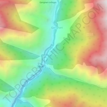
Name: Sungar topographic map, elevation, terrain.

Location: Sungar, Bhatwari, Uttarkashi, Uttarakhand, 249135, India (30.87324 78.65825 30.91324 78.69825)

Average elevation: 2,433 m

Minimum elevation: 1,768 m

Maximum elevation: 3,325 m

Gear up for your next adventure:

Backpacking Tent - Lightweight tent for long-distance hiking trips
🛁Quick-Dry Microfiber Towel - Space-saving towel that dries rapidly on the move
🧭GPS Tracker - Track your location in remote areas safely
🧥Fleece Jacket - Warm and lightweight jacket for layering
🥾Trail Hiking Boots - Supportive boots for rough trails

As an Amazon Associate, this site earns from qualifying purchases at no extra cost to you.