Geolocate

Lilo-an topographic map

Click on the map to display elevation.

About this map

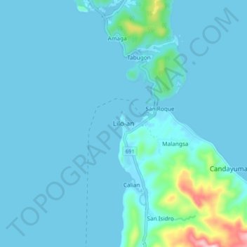
Name: Lilo-an topographic map, elevation, terrain.

Location: Lilo-an, Southern Leyte, Eastern Visayas, 6612, Philippines (10.11632 125.07779 10.19632 125.15779)

Average elevation: 31 m

Minimum elevation: 0 m

Maximum elevation: 370 m

Other topographic maps

Click on a map to view its topography, its elevation and its terrain.

Macrohon

Philippines > Southern Leyte

Average elevation: 33 m

Padre Burgos

Philippines > Southern Leyte

Average elevation: 38 m

Gear up for your next adventure:

🧥Waterproof Hiking Jacket - Protect yourself from rain and wind while hiking
🚲Bike Repair Kit - Essential tools for on-trail mechanical issues
🧴Sunscreen SPF - Broad-spectrum sunscreen for outdoor activities
🥾All-Terrain Hiking Boots - Versatile boots for varied hiking conditions
🔭Compact Binoculars - Lightweight optics for scouting trails and wildlife

As an Amazon Associate, this site earns from qualifying purchases at no extra cost to you.