Geolocate

Mayem topographic map

Click on the map to display elevation.

About this map

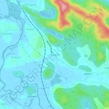
Name: Mayem topographic map, elevation, terrain.

Location: Mayem, Bicholim, North Goa, Goa, 403504, India (15.56695 73.88758 15.60695 73.92758)

Average elevation: 30 m

Minimum elevation: -12 m

Maximum elevation: 165 m

Other topographic maps

Click on a map to view its topography, its elevation and its terrain.

Cudnem River

India > Goa > Bicholim > Amona

Average elevation: 18 m

Gear up for your next adventure:

🕶️Polarized Sunglasses - Reduces glare from snow and water at high elevations
Lightweight Camping Tent - Portable shelter optimized for Canadian backcountry camping
🛶Canoe Life Vest - Safety vest for water sports
🥾Trekking Boots - Durable boots for long-distance trekking
🧤Thermal Hiking Gloves - Grip-enhanced gloves for cold-weather altitude trekking

As an Amazon Associate, this site earns from qualifying purchases at no extra cost to you.