Geolocate

Playa Rica topographic map

Click on the map to display elevation.

About this map

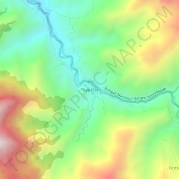
Name: Playa Rica topographic map, elevation, terrain.

Location: Playa Rica, El Tambo, Centro, Cauca, RAP Pacífico, Colombia (2.57448 -77.03705 2.61448 -76.99705)

Average elevation: 922 m

Minimum elevation: 508 m

Maximum elevation: 1,555 m

Other topographic maps

Click on a map to view its topography, its elevation and its terrain.

Río Sucio

Colombia > Cauca > El Tambo

Average elevation: 1,730 m

Gear up for your next adventure:

🛶Waterproof Dry Bags - Keep electronics and clothes dry during river crossings
🧥Softshell Hiking Jacket - The perfect balance of wind protection and breathability
🧢Sun Protection Cap - Breathable cap to protect from sun exposure
Camping Tent - Weather-resistant tents suitable for 2 to 6 people
🌬️Windproof Camp Stove - Efficient cooking even on exposed mountain peaks

As an Amazon Associate, this site earns from qualifying purchases at no extra cost to you.