Geolocate

Kosciusko topographic map

Click on the map to display elevation.

About this map

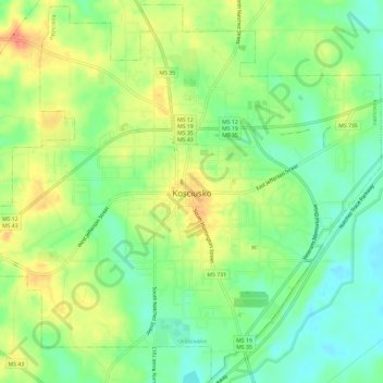
Name: Kosciusko topographic map, elevation, terrain.

Location: Kosciusko, Attala County, Mississippi, 39090, United States (33.03367 -89.61737 33.08199 -89.55845)

Average elevation: 134 m

Minimum elevation: 111 m

Maximum elevation: 162 m

Other topographic maps

Click on a map to view its topography, its elevation and its terrain.

Zama

United States > Mississippi > Attala County

Average elevation: 134 m

Zama

United States > Mississippi > Attala County

Average elevation: 134 m

Gear up for your next adventure:

🏃Hydration Running Vest - Carry water and maps close to your body for speed
🧰Survival Kit - Essential gear for emergencies in the wilderness
🦶Hiking Shoe Insoles - Added support for high arches and long days on feet
🛏️Sleeping Bag - Warm and compact sleeping bags for outdoor camping
🧰Emergency Multi-Tool - Compact multi-tool for outdoor survival

As an Amazon Associate, this site earns from qualifying purchases at no extra cost to you.