
Make a donation
Gear up for your next adventure:
As an Amazon Associate, this site earns from qualifying purchases at no extra cost to you.
Noordschote topographic map
Click on the map to display elevation.
Make a donation
Gear up for your next adventure:
As an Amazon Associate, this site earns from qualifying purchases at no extra cost to you.
Noordschote
Noordschote ligt nabij de IJzer op een hoogte van ongeveer 5 meter. In het westen ligt de Kemmelbeek en in het oosten de Ieperlee met parallel daaraan de Oude Ieperlee, welke bij Drie Grachten, evenals de Steenbeek, in de Ieperlee uitmondt.
Make a donation
Gear up for your next adventure:
As an Amazon Associate, this site earns from qualifying purchases at no extra cost to you.
About this map
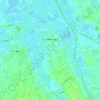
Name: Noordschote topographic map, elevation, terrain.
Location: Noordschote, Lo-Reninge, Diksmuide, West-Vlaanderen, België (50.92678 2.79513 50.97054 2.85644)
Average elevation: 3 m
Minimum elevation: -2 m
Maximum elevation: 10 m
Make a donation
Gear up for your next adventure:
As an Amazon Associate, this site earns from qualifying purchases at no extra cost to you.
Other topographic maps
Click on a map to view its topography, its elevation and its terrain.