
Örebro topographic map
Interactive map
Click on the map to display elevation.
About this map
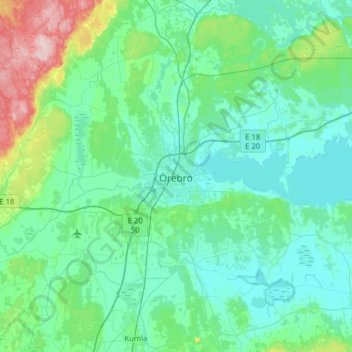
Name: Örebro topographic map, elevation, terrain.
Location: Örebro, Örebro kommun, Örebro County, 703 61, Sweden (59.11473 15.05512 59.43473 15.37512)
Average elevation: 59 m
Minimum elevation: 19 m
Maximum elevation: 294 m
During cold winters, Örebro receives plenty of snowfall. Örebro is far more prone than coastal areas to really harsh frosts with temperatures approaching or below −20 °C (−4 °F) happening almost every winter according to SMHI statistics. The station's setting in a rural location might skew temperatures somewhat compared to the urban area which is also at a slightly lower elevation and nearer Hjälmaren. Especially when considering overnight lows this could result in a small urban heat island effect in downtown.
Other topographic maps
Click on a map to view its topography, its elevation and its terrain.
Hällabrottet
Hällabrottet, Kumla kommun, Örebro County, 692 92, Sweden
Average elevation: 57 m
Karlskoga
Karlskoga, Karlskoga kommun, Örebro County, 691 34, Sweden
Average elevation: 124 m