
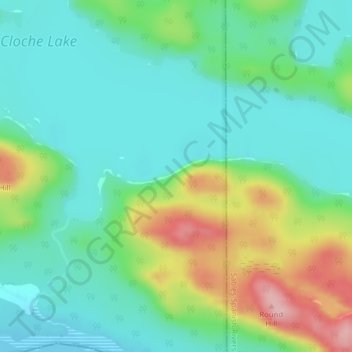
La Cloche Provincial Park topographic map
Interactive map
Click on the map to display elevation.
La Cloche Provincial Park topographic map, elevation, terrain
About this map
Name: La Cloche Provincial Park topographic map, elevation, terrain.
Average elevation: 224 m
Minimum elevation: 175 m
Maximum elevation: 341 m
Other topographic maps
Click on a map to view its topography, its elevation and its terrain.
Webbwood
Canada > Ontario > Sudbury District > Sables-Spanish Rivers Township
Average elevation: 214 m
Kecil Lake
Canada > Ontario > Sudbury District > Sables-Spanish Rivers Township
Average elevation: 239 m
Matheson Island
Canada > Ontario > Sudbury District > Sables-Spanish Rivers Township
Average elevation: 226 m