
Make a donation
Gear up for your next adventure:
As an Amazon Associate, this site earns from qualifying purchases at no extra cost to you.
Mistelbach topographic map
Click on the map to display elevation.
Make a donation
Gear up for your next adventure:
As an Amazon Associate, this site earns from qualifying purchases at no extra cost to you.
About this map
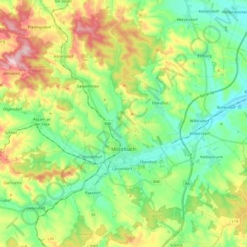
Name: Mistelbach topographic map, elevation, terrain.
Location: Mistelbach, Bezirk Mistelbach, Lower Austria, 2130, Austria (48.51343 16.47471 48.65623 16.70160)
Average elevation: 244 m
Minimum elevation: 176 m
Maximum elevation: 369 m
Make a donation
Gear up for your next adventure:
As an Amazon Associate, this site earns from qualifying purchases at no extra cost to you.
Other topographic maps
Click on a map to view its topography, its elevation and its terrain.
Wolfpassing an der Hochleithen
Austria > Lower Austria > Bezirk Mistelbach > Gemeinde Hochleithen
Average elevation: 241 m
Make a donation
Gear up for your next adventure:
As an Amazon Associate, this site earns from qualifying purchases at no extra cost to you.
Michelstetten
Austria > Lower Austria > Bezirk Mistelbach > Gemeinde Asparn an der Zaya
Average elevation: 320 m
Wolkersdorf im Weinviertel
Austria > Lower Austria > Bezirk Mistelbach > Gemeinde Wolkersdorf im Weinviertel
Average elevation: 206 m