
Poznań topographic map
Interactive map
Click on the map to display elevation.
About this map
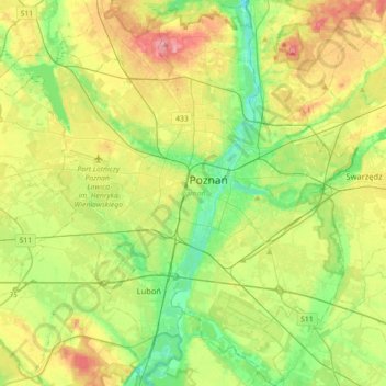
Name: Poznań topographic map, elevation, terrain.
Location: Poznań, Poznań County, Greater Poland Voivodeship, Poland (52.29192 16.73159 52.50933 17.07171)
Average elevation: 85 m
Minimum elevation: 45 m
Maximum elevation: 146 m
Poznań covers an area of 261.3 km2 (100.9 sq mi), and has coordinates in the range 52°17'34''–52°30'27''N, 16°44'08''–17°04'28''E. Its highest point, with an altitude of 157 m (515 ft), is the summit of Morasko hill within the Morasko meteorite nature reserve in the north of the city. The lowest altitude is 60 m (197 ft), in the Warta valley.
Other topographic maps
Click on a map to view its topography, its elevation and its terrain.
Kórnik
Poland > Greater Poland Voivodeship > Poznań County
Kórnik, gmina Kórnik, Poznań County, Greater Poland Voivodeship, 62-035, Poland
Average elevation: 75 m
Owińska
Poland > Greater Poland Voivodeship > Poznań County > Owińska
Owińska, gmina Czerwonak, Poznań County, Greater Poland Voivodeship, 62-009, Poland
Average elevation: 74 m
Mosina
Poland > Greater Poland Voivodeship > Poznań County
Mosina, gmina Mosina, Poznań County, Greater Poland Voivodeship, 62-050, Poland
Average elevation: 71 m
Poznań
Poland > Greater Poland Voivodeship > Poznań County
Poznań, Poznań County, Greater Poland Voivodeship, Poland
Average elevation: 85 m