
Köpenick topographic map
Interactive map
Click on the map to display elevation.
About this map
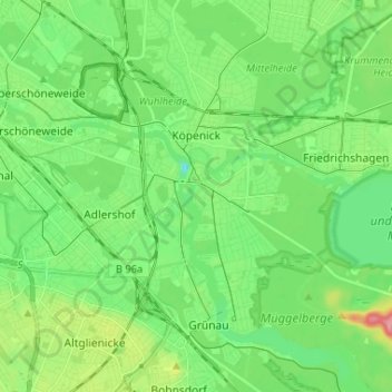
Name: Köpenick topographic map, elevation, terrain.
Location: Köpenick, Treptow-Köpenick, Germany (52.40166 13.54812 52.48112 13.67806)
Average elevation: 39 m
Minimum elevation: 10 m
Maximum elevation: 103 m
Other topographic maps
Click on a map to view its topography, its elevation and its terrain.
Flughafensee
Flughafensee, Tegel, Reinickendorf, Berlin, 13405, Germany
Average elevation: 35 m
Schöneberg
Schöneberg, Tempelhof-Schöneberg, Berlin, Germany
Average elevation: 46 m