Geolocate

Woja topographic map

Click on the map to display elevation.

About this map

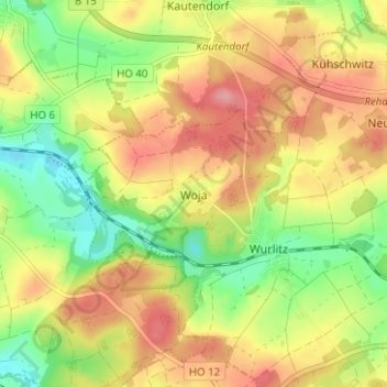
Name: Woja topographic map, elevation, terrain.

Location: Woja, Rehau, Landkreis Hof, Bavaria, 95182, Germany (50.23930 11.95781 50.27930 11.99781)

Average elevation: 538 m

Minimum elevation: 486 m

Maximum elevation: 588 m

Gear up for your next adventure:

🐕Hiking Dog Pack - Let your canine companion carry their own water and food
🧢Sun Protection Cap - Breathable cap to protect from sun exposure
🚲MTB Frame Bag - Carry tools and maps directly on your bicycle frame
🧢Hiking Hat - Sun-protective and breathable hats for long treks
🧴Insect Repellent - Protect yourself from bugs during outdoor adventures

As an Amazon Associate, this site earns from qualifying purchases at no extra cost to you.