
Saint-Pardoux-le-Neuf topographic map
Interactive map
Click on the map to display elevation.
About this map
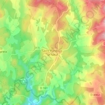
Name: Saint-Pardoux-le-Neuf topographic map, elevation, terrain.
Average elevation: 724 m
Minimum elevation: 644 m
Maximum elevation: 817 m
Other topographic maps
Click on a map to view its topography, its elevation and its terrain.
Saint-Pardoux-le-Neuf
France > Nouvelle-Aquitaine > Saint-Pardoux-le-Neuf
Saint-Pardoux-le-Neuf, Aubusson, Creuse, Nouvelle-Aquitaine, France métropolitaine, 23200, France
Average elevation: 594 m