
Thank you for supporting this site ❤️
Make a donation
Make a donation
Gear up for your next adventure:
As an Amazon Associate, this site earns from qualifying purchases at no extra cost to you.
Bantarujeg topographic map
Click on the map to display elevation.
Thank you for supporting this site ❤️
Make a donation
Make a donation
Gear up for your next adventure:
As an Amazon Associate, this site earns from qualifying purchases at no extra cost to you.
About this map
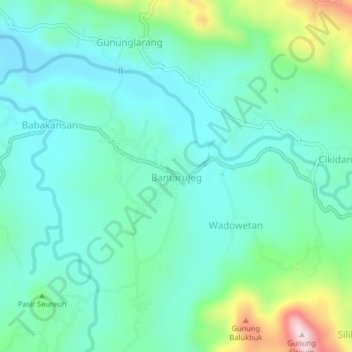
Name: Bantarujeg topographic map, elevation, terrain.
Location: Bantarujeg, Majalengka, West Java, Java, 45465, Indonesia (-6.98531 108.22345 -6.94531 108.26345)
Average elevation: 373 m
Minimum elevation: 278 m
Maximum elevation: 695 m
Thank you for supporting this site ❤️
Make a donation
Make a donation
Gear up for your next adventure:
As an Amazon Associate, this site earns from qualifying purchases at no extra cost to you.