Geolocate

Solokuro topographic map

Click on the map to display elevation.

About this map

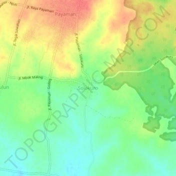
Name: Solokuro topographic map, elevation, terrain.

Location: Solokuro, Lamongan, East Java, Java, Indonesia (-6.95416 112.33760 -6.91416 112.37760)

Average elevation: 40 m

Minimum elevation: 14 m

Maximum elevation: 69 m

Other topographic maps

Click on a map to view its topography, its elevation and its terrain.

Wonorejo

Indonesia > East Java > Lamongan > Sambeng

Average elevation: 81 m

Bluluk

Indonesia > East Java > Lamongan

Average elevation: 73 m

Ngimbang

Indonesia > East Java > Lamongan

Average elevation: 89 m

Pataan

Indonesia > East Java > Lamongan > Sambeng

Average elevation: 102 m

Pamotan

Indonesia > East Java > Lamongan > Sambeng

Average elevation: 78 m

Garung

Indonesia > East Java > Lamongan > Sambeng

Average elevation: 76 m

Selorejo

Indonesia > East Java > Lamongan > Sambeng

Average elevation: 55 m

Sambeng

Indonesia > East Java > Lamongan

Average elevation: 79 m

Sukorame

Indonesia > East Java > Lamongan

Average elevation: 101 m

Jejel

Indonesia > East Java > Lamongan > Ngimbang

Average elevation: 80 m

Gear up for your next adventure:

🧥Packable Rain Jacket - Breathable waterproof layer for unpredictable weather
💧Hydration Bladder - Hands-free hydration solution for long treks
🔭Outdoor Binoculars - Lightweight binoculars for birdwatching and hiking
🦟Insect Repellent - Keep mosquitoes and black flies away in wooded areas
🧼Travel Hand Sanitizer - Keep hands clean when water is scarce

As an Amazon Associate, this site earns from qualifying purchases at no extra cost to you.