
Make a donation
Gear up for your next adventure:
As an Amazon Associate, this site earns from qualifying purchases at no extra cost to you.
Kamal topographic map
Click on the map to display elevation.
Make a donation
Gear up for your next adventure:
As an Amazon Associate, this site earns from qualifying purchases at no extra cost to you.
Kamal
Sahand is one of the highest mountains in Iranian Azerbaijan, in addition to being an important dormant volcano in the country. The Sahand mountains are directly south of Tabriz, the highest peak of which is Kamal at an elevation of 3,707 m (12,162 ft). Approximately 17 peaks can be accounted for as being over 3,000 m (9,843 ft) in height. Due to the presence of a variety of flora and fauna, the Sahand mountains are known as the bride of mountains in Iran. Sahand is made chiefly of dacite and associated felsic rocks.
Make a donation
Gear up for your next adventure:
As an Amazon Associate, this site earns from qualifying purchases at no extra cost to you.
About this map
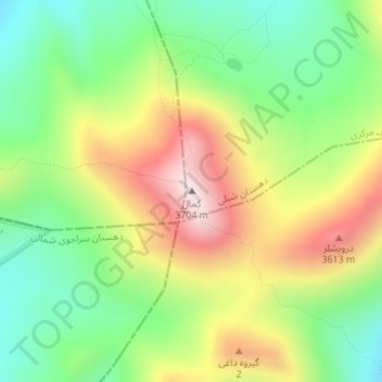
Name: Kamal topographic map, elevation, terrain.
Average elevation: 3,335 m
Minimum elevation: 3,071 m
Maximum elevation: 3,698 m
Make a donation
Gear up for your next adventure:
As an Amazon Associate, this site earns from qualifying purchases at no extra cost to you.