
Thank you for supporting this site ❤️
Make a donation
Make a donation
Gear up for your next adventure:
As an Amazon Associate, this site earns from qualifying purchases at no extra cost to you.
Arse topographic map
Click on the map to display elevation.
Thank you for supporting this site ❤️
Make a donation
Make a donation
Gear up for your next adventure:
As an Amazon Associate, this site earns from qualifying purchases at no extra cost to you.
About this map
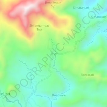
Name: Arse topographic map, elevation, terrain.
Location: Arse, Northern Padang Lawas, North Sumatra, Sumatra, Indonesia (1.87111 99.64032 1.91111 99.68032)
Average elevation: 418 m
Minimum elevation: 143 m
Maximum elevation: 952 m
Thank you for supporting this site ❤️
Make a donation
Make a donation
Gear up for your next adventure:
As an Amazon Associate, this site earns from qualifying purchases at no extra cost to you.
Other topographic maps
Click on a map to view its topography, its elevation and its terrain.
Batang Onang
Indonesia > North Sumatra > Northern Padang Lawas > Sayur Matinggi Ii (julu)
Average elevation: 275 m