Geolocate

Borgomaro topographic map

Click on the map to display elevation.

About this map

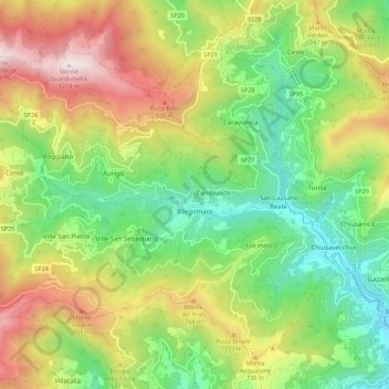
Name: Borgomaro topographic map, elevation, terrain.

Location: Borgomaro, Provincia di Imperia, Liguria, 18021, Italy (43.95205 7.86123 44.00446 7.97090)

Average elevation: 535 m

Minimum elevation: 85 m

Maximum elevation: 1,204 m

Other topographic maps

Click on a map to view its topography, its elevation and its terrain.

Montalto Ligure

Italy > Liguria > Provincia di Imperia

Average elevation: 529 m

Bestagno

Italy > Liguria > Provincia di Imperia > Pontedassio

Average elevation: 274 m

Gear up for your next adventure:

🥾Mountain Trail Shoes - High-traction shoes for mountain trails
🥾Trekking Poles - Adjustable trekking poles to reduce knee stress and improve stability
🏕️Camping Hammock - Integrated protection for sleeping between trees
🥾Lightweight Hiking Boots - Boots for comfort and mobility on long hikes
🥾Light Trekking Boots - Supportive boots for multi-day treks

As an Amazon Associate, this site earns from qualifying purchases at no extra cost to you.