
Reiferscheid topographic map
Click on the map to display elevation.
About this map
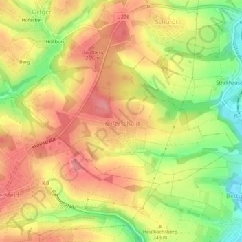
Name: Reiferscheid topographic map, elevation, terrain.
Average elevation: 240 m
Minimum elevation: 185 m
Maximum elevation: 279 m
Other topographic maps
Click on a map to view its topography, its elevation and its terrain.
Wingendorf
Germany > Rhineland-Palatinate > Landkreis Altenkirchen (Westerwald)
Average elevation: 285 m
Erbel
Germany > Rhineland-Palatinate > Landkreis Altenkirchen (Westerwald) > Fluterschen
Average elevation: 281 m
Dünebusch
Germany > Rhineland-Palatinate > Landkreis Altenkirchen (Westerwald) > Bitzen
Average elevation: 206 m