Geolocate

Bolsward topographic map

Click on the map to display elevation.

About this map

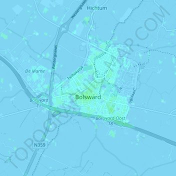
Name: Bolsward topographic map, elevation, terrain.

Location: Bolsward, Súdwest-Fryslân, Frisia, Netherlands (53.04561 5.49142 53.08226 5.55732)

Average elevation: 0 m

Minimum elevation: -3 m

Maximum elevation: 4 m

Other topographic maps

Click on a map to view its topography, its elevation and its terrain.

Ypecolsga

Netherlands > Frisia > Ypecolsga

Average elevation: -1 m

Gear up for your next adventure:

🌡️Emergency Mylar Blankets - Compact thermal protection for unexpected nights outdoors
💧Filtered Water Bottle - Safe drinking water on the go
🧥Waterproof Pants - Keep dry during rainy hiking conditions
Bushcraft Tarp - Versatile emergency shelter or gear protection
🧥Softshell Jacket - Windproof and breathable jacket for hiking

As an Amazon Associate, this site earns from qualifying purchases at no extra cost to you.