Geolocate

Verín topographic map

Click on the map to display elevation.

About this map

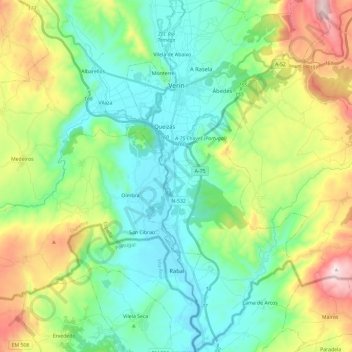
Name: Verín topographic map, elevation, terrain.

Location: Verín, Ourense, Galicia, Spain (41.80736 -7.47433 41.98303 -7.35277)

Average elevation: 571 m

Minimum elevation: 357 m

Maximum elevation: 1,083 m

Other topographic maps

Click on a map to view its topography, its elevation and its terrain.

Mandín

Spain > Galicia > Verín

Average elevation: 443 m

As Vendas da Barreira

Spain > Galicia > Verín > Riós

Average elevation: 802 m

San Pedro de Trasverea

Spain > Galicia > Verín > Riós

Average elevation: 894 m

Gear up for your next adventure:

🧭GPS Outdoor Watch - Smart watch for navigation and fitness tracking in nature
🧥Thermal Layer - Insulating layer for cold outdoor conditions
🧦Merino Wool Socks - Moisture-wicking comfort for long-distance hiking
🧥Softshell Hiking Jacket - The perfect balance of wind protection and breathability
🧴Outdoor Sunscreen - High SPF protection for high-altitude UV exposure

As an Amazon Associate, this site earns from qualifying purchases at no extra cost to you.