Geolocate

Comstock topographic map

Click on the map to display elevation.

About this map

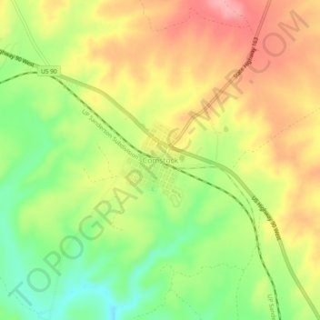
Name: Comstock topographic map, elevation, terrain.

Location: Comstock, Val Verde County, Texas, United States (29.66496 -101.19430 29.70496 -101.15430)

Average elevation: 476 m

Minimum elevation: 420 m

Maximum elevation: 527 m

Other topographic maps

Click on a map to view its topography, its elevation and its terrain.

Del Rio

United States > Texas > Val Verde County

Average elevation: 311 m

Del Rio

United States > Texas > Val Verde County

Average elevation: 310 m

Gear up for your next adventure:

Camping Tent - Weather-resistant tents suitable for 2 to 6 people
💧Collapsible Water Bottle - Space-saving water bottle for outdoor activities
🥽Outdoor Goggles - Protective eyewear for outdoor activities
🧴Insect Repellent - Protect yourself from bugs during outdoor adventures
🛰️Satellite Messenger - Emergency communication for areas with no cell service

As an Amazon Associate, this site earns from qualifying purchases at no extra cost to you.