Geolocate

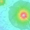
Dap-Dap topographic map

Click on the map to display elevation.

About this map

Name: Dap-Dap topographic map, elevation, terrain.

Location: Dap-Dap, Legazpi, Albay, Bicol Region, 4500, Philippines (13.12080 123.73815 13.16080 123.77815)

Average elevation: 15 m

Minimum elevation: 0 m

Maximum elevation: 112 m

Other topographic maps

Click on a map to view its topography, its elevation and its terrain.

Tibu River

Philippines > Albay > Legazpi > Tamaoyan

Average elevation: 4 m

Mayon Volcano

Philippines > Albay > Legazpi

Average elevation: 519 m

Sawangan Park

Philippines > Albay > Legazpi

Average elevation: 7 m

Kalayaan Park

Philippines > Albay > Legazpi

Average elevation: 7 m

Gear up for your next adventure:

🔋Solar Power Bank - Keep your GPS and devices charged during long outdoor trips
🕯️Camping Lantern - Illuminates your entire campsite with high-efficiency LEDs
🧭GPS Tracker - Track your location in remote areas safely
⛺Camping Essentials - All-in-one gear for a comfortable camping trip
🔥Camping Stove - Portable stoves to cook outdoors with ease

As an Amazon Associate, this site earns from qualifying purchases at no extra cost to you.