
Make a donation
Gear up for your next adventure:
As an Amazon Associate, this site earns from qualifying purchases at no extra cost to you.
Diriamba topographic map
Click on the map to display elevation.
Make a donation
Gear up for your next adventure:
As an Amazon Associate, this site earns from qualifying purchases at no extra cost to you.
Diriamba
The city's elevation (just above 500 meters above sea level), and the geography of the cordillera upon which it sits, lend it a constantly mild weather (though notoriously windy January through March).
Make a donation
Gear up for your next adventure:
As an Amazon Associate, this site earns from qualifying purchases at no extra cost to you.
About this map
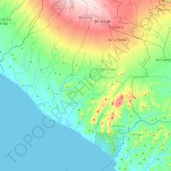
Name: Diriamba topographic map, elevation, terrain.
Location: Diriamba, Carazo, 46300, Nicaragua (11.49292 -86.58358 11.89648 -86.21504)
Average elevation: 167 m
Minimum elevation: 0 m
Maximum elevation: 675 m
Make a donation
Gear up for your next adventure:
As an Amazon Associate, this site earns from qualifying purchases at no extra cost to you.