
Thank you for supporting this site ❤️
Make a donation
Make a donation
Gear up for your next adventure:
As an Amazon Associate, this site earns from qualifying purchases at no extra cost to you.
Coscullano topographic map
Click on the map to display elevation.
Thank you for supporting this site ❤️
Make a donation
Make a donation
Gear up for your next adventure:
As an Amazon Associate, this site earns from qualifying purchases at no extra cost to you.
About this map
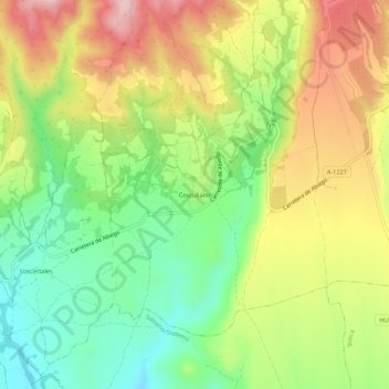
Name: Coscullano topographic map, elevation, terrain.
Average elevation: 675 m
Minimum elevation: 565 m
Maximum elevation: 807 m
Thank you for supporting this site ❤️
Make a donation
Make a donation
Gear up for your next adventure:
As an Amazon Associate, this site earns from qualifying purchases at no extra cost to you.
Other topographic maps
Click on a map to view its topography, its elevation and its terrain.
Santa Eulalia la Mayor
Espagne > Aragon > Hoya de Huesca / Plana de Uesca > Loporzano
Average elevation: 946 m
San Julián de Banzo
Espagne > Aragon > Hoya de Huesca / Plana de Uesca > Loporzano
Average elevation: 876 m