Geolocate

Hundon topographic map

Click on the map to display elevation.

About this map

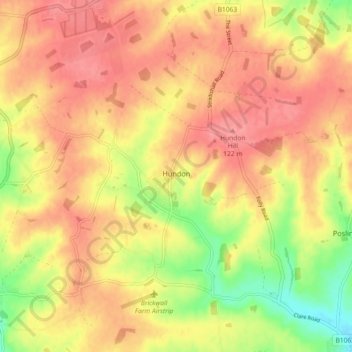
Name: Hundon topographic map, elevation, terrain.

Location: Hundon, Suffolk, England, United Kingdom (52.08466 0.50233 52.14059 0.57235)

Average elevation: 97 m

Minimum elevation: 49 m

Maximum elevation: 124 m

Gear up for your next adventure:

🛰️Satellite Messenger - Emergency communication for areas with no cell service
🔦UV Flashlight - Detect minerals or specific insects in the dark
🧴Waterproofing Spray - Restore the DWR coating on jackets and tents
🧼Travel Hand Sanitizer - Keep hands clean when water is scarce
🧢Outdoor Visor - Breathable visor for sunny hikes

As an Amazon Associate, this site earns from qualifying purchases at no extra cost to you.