
Make a donation
Gear up for your next adventure:
As an Amazon Associate, this site earns from qualifying purchases at no extra cost to you.
Beaver Falls topographic map
Click on the map to display elevation.
Make a donation
Gear up for your next adventure:
As an Amazon Associate, this site earns from qualifying purchases at no extra cost to you.
About this map
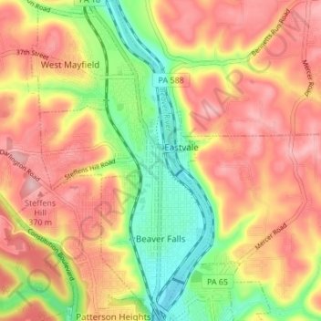
Name: Beaver Falls topographic map, elevation, terrain.
Location: Beaver Falls, Beaver County, Pennsylvania, United States (40.73884 -80.33521 40.79034 -80.30858)
Average elevation: 311 m
Minimum elevation: 213 m
Maximum elevation: 390 m
Make a donation
Gear up for your next adventure:
As an Amazon Associate, this site earns from qualifying purchases at no extra cost to you.
Other topographic maps
Click on a map to view its topography, its elevation and its terrain.
Ambridge Heights
United States > Pennsylvania > Beaver County > Harmony Township
Average elevation: 278 m
Rowtown
United States > Pennsylvania > Beaver County > South Beaver Township > Rowtown
Average elevation: 322 m
Make a donation
Gear up for your next adventure:
As an Amazon Associate, this site earns from qualifying purchases at no extra cost to you.