
Make a donation
Gear up for your next adventure:
As an Amazon Associate, this site earns from qualifying purchases at no extra cost to you.
Hammersfeld topographic map
Click on the map to display elevation.
Make a donation
Gear up for your next adventure:
As an Amazon Associate, this site earns from qualifying purchases at no extra cost to you.
Hammersfeld
Hammersfeld liegt östlich der Ilm in etwa 400 Metern Höhe. Südlich von Hammersfeld erhebt sich der Singer Berg (583 m), östlich liegt das Tal der Deube. Nachbarorte sind Griesheim im Westen, Stadtilm im Norden, Geilsdorf im Osten und Dörnfeld an der Ilm im Südwesten.
Make a donation
Gear up for your next adventure:
As an Amazon Associate, this site earns from qualifying purchases at no extra cost to you.
About this map
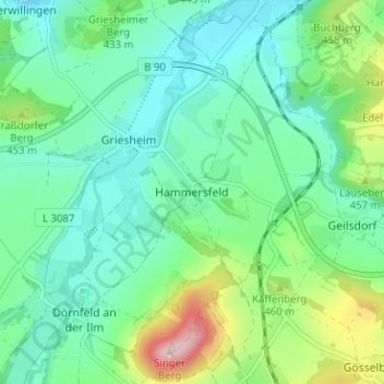
Name: Hammersfeld topographic map, elevation, terrain.
Average elevation: 416 m
Minimum elevation: 360 m
Maximum elevation: 578 m
Make a donation
Gear up for your next adventure:
As an Amazon Associate, this site earns from qualifying purchases at no extra cost to you.