
Make a donation
Gear up for your next adventure:
As an Amazon Associate, this site earns from qualifying purchases at no extra cost to you.
Anost topographic map
Click on the map to display elevation.
Make a donation
Gear up for your next adventure:
As an Amazon Associate, this site earns from qualifying purchases at no extra cost to you.
About this map
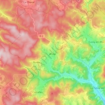
Name: Anost topographic map, elevation, terrain.
Average elevation: 585 m
Minimum elevation: 343 m
Maximum elevation: 796 m
Make a donation
Gear up for your next adventure:
As an Amazon Associate, this site earns from qualifying purchases at no extra cost to you.
Other topographic maps
Click on a map to view its topography, its elevation and its terrain.
Sous le Bois de Leynes
Frankrijk > Bourgondië-Franche-Comté > Saône-et-Loire > Leynes
Average elevation: 401 m
Labergement
Frankrijk > Bourgondië-Franche-Comté > Saône-et-Loire > Montpont-en-Bresse
Average elevation: 201 m
Les Gendrons
Frankrijk > Bourgondië-Franche-Comté > Saône-et-Loire > Tramayes
Average elevation: 469 m
Make a donation
Gear up for your next adventure:
As an Amazon Associate, this site earns from qualifying purchases at no extra cost to you.
La Charme
Frankrijk > Bourgondië-Franche-Comté > Saône-et-Loire > Ouroux-sur-Saône
Average elevation: 184 m
Sagy-le-Haut
Frankrijk > Bourgondië-Franche-Comté > Saône-et-Loire > Cruzille
Average elevation: 350 m
La Chavonnaise
Frankrijk > Bourgondië-Franche-Comté > Saône-et-Loire > Montpont-en-Bresse
Average elevation: 200 m
Make a donation
Gear up for your next adventure:
As an Amazon Associate, this site earns from qualifying purchases at no extra cost to you.
Les Pignots
Frankrijk > Bourgondië-Franche-Comté > Saône-et-Loire > Anost > Les Pignots
Average elevation: 598 m
Hameau du Château
Frankrijk > Bourgondië-Franche-Comté > Saône-et-Loire > Rully > Hameau du Château
Average elevation: 275 m
Make a donation
Gear up for your next adventure:
As an Amazon Associate, this site earns from qualifying purchases at no extra cost to you.
Mont Beuvray
Frankrijk > Bourgondië-Franche-Comté > Saône-et-Loire > Saint-Léger-sous-Beuvray
Average elevation: 632 m
Champagne
Frankrijk > Bourgondië-Franche-Comté > Saône-et-Loire > Culles-les-Roches
Average elevation: 357 m