
Make a donation
Gear up for your next adventure:
As an Amazon Associate, this site earns from qualifying purchases at no extra cost to you.
Ilave topographic map
Click on the map to display elevation.
Make a donation
Gear up for your next adventure:
As an Amazon Associate, this site earns from qualifying purchases at no extra cost to you.
Ilave
La ciudad de Ilave se encuentra a una altitud de 3850 metros sobre el nivel del mar, en la región de la sierra, con un declive hacia el sudeste en la zona urbana.
Make a donation
Gear up for your next adventure:
As an Amazon Associate, this site earns from qualifying purchases at no extra cost to you.
About this map
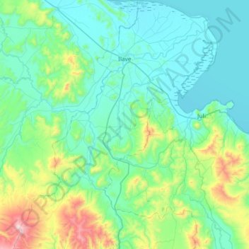
Name: Ilave topographic map, elevation, terrain.
Location: Ilave, Provincia de El Collao, Puno, Perú (-16.51299 -69.88447 -15.95577 -69.44759)
Average elevation: 4,030 m
Minimum elevation: 3,808 m
Maximum elevation: 5,164 m
Make a donation
Gear up for your next adventure:
As an Amazon Associate, this site earns from qualifying purchases at no extra cost to you.