Geolocate

Bulbulungan topographic map

Click on the map to display elevation.

About this map

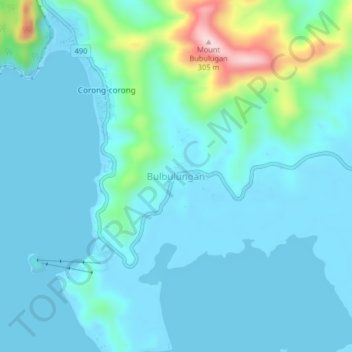
Name: Bulbulungan topographic map, elevation, terrain.

Location: Bulbulungan, El Nido, Palawan, Mimaropa, 5313, Philippines (11.13532 119.38651 11.17532 119.42651)

Average elevation: 44 m

Minimum elevation: -1 m

Maximum elevation: 305 m

Other topographic maps

Click on a map to view its topography, its elevation and its terrain.

Shimizu Island

Philippines > Palawan > El Nido

Average elevation: 18 m

Miniloc Island

Philippines > Palawan > El Nido

Average elevation: 27 m

South Guntao Island

Philippines > Palawan > El Nido

Average elevation: 7 m

Nacpan Beach

Philippines > Palawan > El Nido > Calitang

Average elevation: 36 m

Lio Beach

Philippines > Palawan > El Nido > Villa Libertad

Average elevation: 13 m

Gear up for your next adventure:

🧼Biodegradable Camp Soap - Environmentally friendly cleaning for gear and body
🥾All-Terrain Hiking Boots - Versatile boots for varied hiking conditions
🛏️Sleeping Bag - Warm and compact sleeping bags for outdoor camping
🦶Anti-Blister Balm - Prevents friction and hotspots during long ascents
🥾Light Trekking Boots - Supportive boots for multi-day treks

As an Amazon Associate, this site earns from qualifying purchases at no extra cost to you.