Geolocate

Elba topographic map

Click on the map to display elevation.

About this map

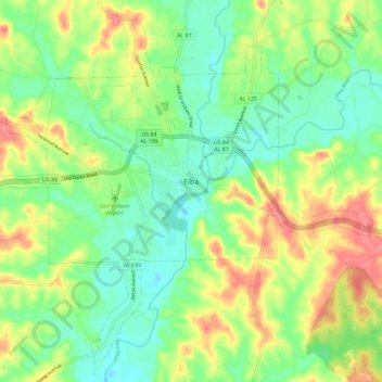
Name: Elba topographic map, elevation, terrain.

Location: Elba, Coffee County, Alabama, 36323, United States (31.36791 -86.12777 31.45610 -86.01279)

Average elevation: 80 m

Minimum elevation: 48 m

Maximum elevation: 130 m

Other topographic maps

Click on a map to view its topography, its elevation and its terrain.

Brooklyn

United States > Alabama > Coffee County

Average elevation: 87 m

Gear up for your next adventure:

Family Camping Tent - Spacious tent suitable for family camping trips
🧥Softshell Hiking Jacket - The perfect balance of wind protection and breathability
🥾Hiking Shorts - Breathable shorts suitable for summer hikes
🥾Lightweight Hiking Shoes - Comfortable shoes for day hikes
🥾Approach Shoes - Shoes designed for climbing approaches and rugged trails

As an Amazon Associate, this site earns from qualifying purchases at no extra cost to you.