Geolocate

Brezje topographic map

Click on the map to display elevation.

About this map

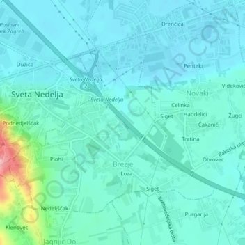
Name: Brezje topographic map, elevation, terrain.

Location: Brezje, Grad Sveta Nedelja, Zagreb County, 10431, Croatia (45.78365 15.77228 45.80345 15.80479)

Average elevation: 143 m

Minimum elevation: 121 m

Maximum elevation: 261 m

Gear up for your next adventure:

💡LED Camping Lantern - Illuminate your campsite with long-lasting lanterns
🦯Trekking Poles - Reduced impact on joints for steep topographic climbs
🪜Heavy Duty Carabiners - Multi-use clips for securing gear to your backpack
🧰Survival Kit - Essential gear for emergencies in the wilderness
🛶Canoe Life Vest - Safety vest for water sports

As an Amazon Associate, this site earns from qualifying purchases at no extra cost to you.