
Thank you for supporting this site ❤️
Make a donation
Make a donation
Gear up for your next adventure:
As an Amazon Associate, this site earns from qualifying purchases at no extra cost to you.
Maddalena topographic map
Click on the map to display elevation.
Thank you for supporting this site ❤️
Make a donation
Make a donation
Gear up for your next adventure:
As an Amazon Associate, this site earns from qualifying purchases at no extra cost to you.
About this map
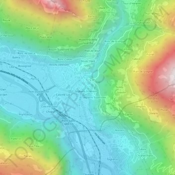
Name: Maddalena topographic map, elevation, terrain.
Location: Maddalena, Pont-Saint-Martin, Aostatal, 11026, Italien (45.57666 7.78103 45.61666 7.82103)
Average elevation: 663 m
Minimum elevation: 283 m
Maximum elevation: 1,596 m
Thank you for supporting this site ❤️
Make a donation
Make a donation
Gear up for your next adventure:
As an Amazon Associate, this site earns from qualifying purchases at no extra cost to you.