
Make a donation
Gear up for your next adventure:
As an Amazon Associate, this site earns from qualifying purchases at no extra cost to you.
Budhanilkantha-11 topographic map
Click on the map to display elevation.
Make a donation
Gear up for your next adventure:
As an Amazon Associate, this site earns from qualifying purchases at no extra cost to you.
About this map
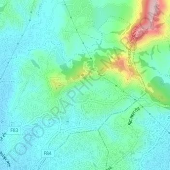
Name: Budhanilkantha-11 topographic map, elevation, terrain.
Average elevation: 1,368 m
Minimum elevation: 1,315 m
Maximum elevation: 1,551 m
Make a donation
Gear up for your next adventure:
As an Amazon Associate, this site earns from qualifying purchases at no extra cost to you.
Other topographic maps
Click on a map to view its topography, its elevation and its terrain.
Make a donation
Gear up for your next adventure:
As an Amazon Associate, this site earns from qualifying purchases at no extra cost to you.
Mulpani Pipalbot
Nepal > Bagamati Province > Kathmandu > Kageshwori Manohara
Average elevation: 1,336 m
Make a donation
Gear up for your next adventure:
As an Amazon Associate, this site earns from qualifying purchases at no extra cost to you.
Sundhara
Nepal > Bagamati Province > Kathmandu > Kathmandu Metropolitan City
Average elevation: 1,299 m
Make a donation
Gear up for your next adventure:
As an Amazon Associate, this site earns from qualifying purchases at no extra cost to you.