Geolocate

Kericho topographic map

Click on the map to display elevation.

About this map

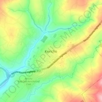
Name: Kericho topographic map, elevation, terrain.

Location: Kericho, Ainamoi, Kericho County, Kenya (-0.38309 35.26448 -0.34976 35.30226)

Average elevation: 1,988 m

Minimum elevation: 1,913 m

Maximum elevation: 2,081 m

Gear up for your next adventure:

🚑Survival Whistle - Signal for help across long distances in mountains
🧦Hiking Liner Socks - Thin base layer to prevent friction and blisters
🥾Hiking Gaiters - Protect legs and shoes from mud, snow, and debris
🚲MTB Frame Bag - Carry tools and maps directly on your bicycle frame
🔥Camping Stove - Portable stoves to cook outdoors with ease

As an Amazon Associate, this site earns from qualifying purchases at no extra cost to you.