
Thank you for supporting this site ❤️
Make a donation
Make a donation
Gear up for your next adventure:
As an Amazon Associate, this site earns from qualifying purchases at no extra cost to you.
Zoznegg topographic map
Click on the map to display elevation.
Thank you for supporting this site ❤️
Make a donation
Make a donation
Gear up for your next adventure:
As an Amazon Associate, this site earns from qualifying purchases at no extra cost to you.
Zoznegg
Zoznegg liegt im Nordosten des Hegaus, am Übergang zum Linzgau, etwa zweieinhalb Kilometer südöstlich der Mühlinger Ortsmitte, auf einer Höhe zwischen 582 und 683,7 m ü. NHN im „Bergholz“.
Thank you for supporting this site ❤️
Make a donation
Make a donation
Gear up for your next adventure:
As an Amazon Associate, this site earns from qualifying purchases at no extra cost to you.
About this map
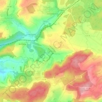
Name: Zoznegg topographic map, elevation, terrain.
Average elevation: 632 m
Minimum elevation: 552 m
Maximum elevation: 702 m
Thank you for supporting this site ❤️
Make a donation
Make a donation
Gear up for your next adventure:
As an Amazon Associate, this site earns from qualifying purchases at no extra cost to you.