
Make a donation
Gear up for your next adventure:
As an Amazon Associate, this site earns from qualifying purchases at no extra cost to you.
Santiago de Compostela topographic map
Click on the map to display elevation.
Make a donation
Gear up for your next adventure:
As an Amazon Associate, this site earns from qualifying purchases at no extra cost to you.
Santiago de Compostela
According to medieval legend, the remains of the apostle James, son of Zebedee were brought to Galicia for burial, where they were lost. Eight hundred years later the light of a bright star guided a shepherd, Pelagius the Hermit, who was watching his flock at night to the burial site in Santiago de Compostela. This site was originally called Mount Libredon [gl] and its physical topography leads prevalent sea borne winds to clear the cloud deck immediately overhead. The shepherd quickly reported his discovery to the bishop of Iria, Theodemir. The bishop declared that the remains were those of the apostle James and immediately notified King Alfonso II in Oviedo. To honour St. James, the cathedral was built on the spot where his remains were said to have been found. The legend, which included numerous miraculous events, enabled the Catholic faithful to bolster support for their stronghold in northern Spain during the Christian crusades against the Moors, but also led to the growth and development of the city.
Make a donation
Gear up for your next adventure:
As an Amazon Associate, this site earns from qualifying purchases at no extra cost to you.
About this map
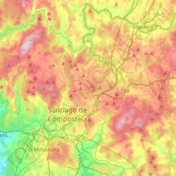
Name: Santiago de Compostela topographic map, elevation, terrain.
Location: Santiago de Compostela, Santiago, A Coruña, Galicia, Spain (42.82414 -8.63201 42.98963 -8.39009)
Average elevation: 277 m
Minimum elevation: 34 m
Maximum elevation: 527 m
Make a donation
Gear up for your next adventure:
As an Amazon Associate, this site earns from qualifying purchases at no extra cost to you.