
Thank you for supporting this site ❤️
Make a donation
Make a donation
Gear up for your next adventure:
As an Amazon Associate, this site earns from qualifying purchases at no extra cost to you.
Fornelli topographic map
Click on the map to display elevation.
Thank you for supporting this site ❤️
Make a donation
Make a donation
Gear up for your next adventure:
As an Amazon Associate, this site earns from qualifying purchases at no extra cost to you.
About this map
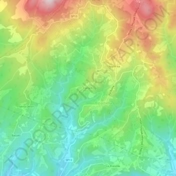
Name: Fornelli topographic map, elevation, terrain.
Location: Fornelli, Riparbella, Pisa, Toscana, 56046, Italia (43.34798 10.57468 43.38798 10.61468)
Average elevation: 212 m
Minimum elevation: 23 m
Maximum elevation: 508 m
Thank you for supporting this site ❤️
Make a donation
Make a donation
Gear up for your next adventure:
As an Amazon Associate, this site earns from qualifying purchases at no extra cost to you.
Other topographic maps
Click on a map to view its topography, its elevation and its terrain.
Area naturale protetta di interesse locale Giardino Belora, Fiume Cecina
Italia > Toscana > Pisa > Riparbella
Average elevation: 88 m