Geolocate

Balaoang topographic map

Click on the map to display elevation.

About this map

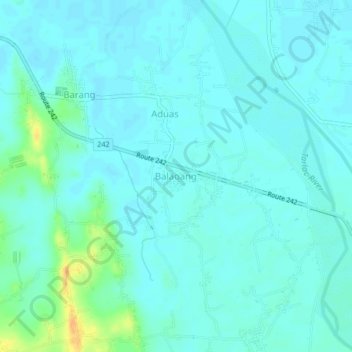
Name: Balaoang topographic map, elevation, terrain.

Location: Balaoang, Paniqui, Tarlac, Central Luzon, 2307, Philippines (15.64342 120.49290 15.68342 120.53290)

Average elevation: 22 m

Minimum elevation: 16 m

Maximum elevation: 48 m

Gear up for your next adventure:

🎒Backpack Rain Cover - External shield to keep your entire pack dry
🧴Waterproofing Spray - Restore the DWR coating on jackets and tents
🚑Survival Whistle - Signal for help across long distances in mountains
🧥Softshell Jacket - Windproof and breathable jacket for hiking
🧣Evaporative Cooling Towel - Beat the heat during intense summer climbs

As an Amazon Associate, this site earns from qualifying purchases at no extra cost to you.