Geolocate

Hazaribagh topographic map

Click on the map to display elevation.

About this map

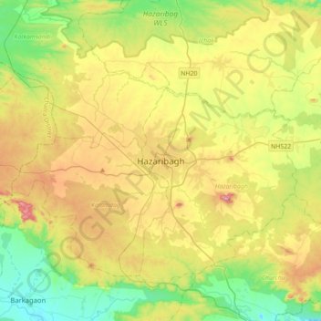
Name: Hazaribagh topographic map, elevation, terrain.

Location: Hazaribagh, Jharkhand, 825300, India (23.83244 85.20163 24.15244 85.52163)

Average elevation: 563 m

Minimum elevation: 391 m

Maximum elevation: 838 m

Gear up for your next adventure:

🧥Softshell Hiking Jacket - The perfect balance of wind protection and breathability
🧴Waterproofing Spray - Restore the DWR coating on jackets and tents
🔦LED Headtorch - Bright and durable light for night activities
🕶️Polarized Sunglasses - Reduces glare from snow and water at high elevations
🥾Trail Hiking Boots - Supportive boots for rough trails

As an Amazon Associate, this site earns from qualifying purchases at no extra cost to you.