Geolocate

Santa Margalida topographic map

Click on the map to display elevation.

About this map

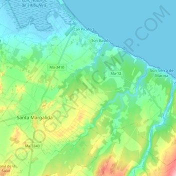
Name: Santa Margalida topographic map, elevation, terrain.

Location: Santa Margalida, Pla de Mallorca, Balearic Islands, Spain (39.67575 3.07023 39.77390 3.23758)

Average elevation: 43 m

Minimum elevation: -3 m

Maximum elevation: 254 m

Other topographic maps

Click on a map to view its topography, its elevation and its terrain.

Sa Figuera

Spain > Balearic Islands > Pla de Mallorca > Montuïri

Average elevation: 159 m

Ruberts

Spain > Balearic Islands > Pla de Mallorca > Sencelles

Average elevation: 124 m

Son Cortana

Spain > Balearic Islands > Pla de Mallorca > Algaida

Average elevation: 185 m

Judí

Spain > Balearic Islands > Pla de Mallorca > Sencelles > Ruberts

Average elevation: 108 m

Gear up for your next adventure:

🧢Sun Protection Cap - Breathable cap to protect from sun exposure
Camping Essentials - All-in-one gear for a comfortable camping trip
Tent Footprint - Protect tent floor and increase durability
🧥Softshell Jacket - Windproof and breathable jacket for hiking
🥾Trail Hiking Socks - Comfortable socks to prevent blisters and fatigue

As an Amazon Associate, this site earns from qualifying purchases at no extra cost to you.